

Shipping Safety Control Zones Order (C.R.C., c. 356)
Full Document:
- HTMLFull Document: Shipping Safety Control Zones Order (Accessibility Buttons available) |
- XMLFull Document: Shipping Safety Control Zones Order [21 KB] |
- PDFFull Document: Shipping Safety Control Zones Order [3446 KB]
Regulations are current to 2024-04-01 and last amended on 2010-06-10. Previous Versions
Shipping Safety Control Zones Order
C.R.C., c. 356
ARCTIC WATERS POLLUTION PREVENTION ACT
Order Prescribing Certain Areas of the Arctic Waters as Shipping Safety Control Zones
Short Title
1 This Order may be cited as the Shipping Safety Control Zones Order.
Interpretation
2 In this Order, seaward boundary means the outer limit of the exclusive economic zone of Canada. However, where the international boundary between Canada and Greenland is less than 200 nautical miles from the baselines of the territorial sea of Canada, the international boundary shall be substituted for that outer limit.
- SOR/2010-131, s. 1
Shipping Safety Control Zones
3 The areas of the arctic waters described in the zones set out in Schedule 1 and shown in Schedule 2, other than any rivers, lakes or other fresh waters, are hereby prescribed as shipping safety control zones.
- SOR/2010-131, s. 1
SCHEDULE 1(Section 3)
Zone 1
COMMENCING at latitude 76°40′, longitude 99°00′; THENCE along parallel of latitude 76°40′, to longitude 96°25′; THENCE along a line to latitude 80°25′, longitude 88°00′; THENCE along a line to the intersection of latitude 82°00′ with the seaward boundary in Robeson Channel; THENCE along the seaward boundary northerly and southwesterly to longitude 141°00′; THENCE along meridian of longitude 141°00′ to latitude 71°20′; THENCE along a line to latitude 71°15′, longitude 137°00′; THENCE along a line to latitude 71°30′, longitude 134°00′; THENCE along a line to latitude 72°00′, longitude 131°30′; THENCE along a line to latitude 72°40′, longitude 131°00′; THENCE along a line to the most westerly intersection of latitude 74°20′ with the shore of Banks Island, near Cape Prince Alfred; THENCE along the northerly and northeasterly shore of Banks Island to its most easterly intersection with latitude 73°30′, near Russell Point; THENCE along a line to latitude 74°30′, longitude 112°50′; THENCE along a line to latitude 75°30′, longitude 106°10′; THENCE along a line to latitude 75°50′, longitude 99°00′; THENCE along meridian of longitude 99°00′ to the point of commencement.
Zone 2
COMMENCING at latitude 74°30′, longitude 99°00′; THENCE along parallel of latitude 74°30′, to longitude 112°50′; THENCE along a line to the most easterly intersection of latitude 73°30′ with the shore of Banks Island, near Russell Point; THENCE along the easterly shore of Banks Island to its most easterly intersection with latitude 72°45′; THENCE along parallel of latitude 72°45′, to longitude 117°20′; THENCE along a line to latitude 70°00′, longitude 110°00′; THENCE along parallel of latitude 70°00′, to longitude 99°00′; THENCE along meridian of longitude 99°00′ to the point of commencement.
Zone 3
COMMENCING at latitude 76°40′, longitude 96°25′; THENCE along parallel of latitude 76°40′ to longitude 88°30′; THENCE along a line to latitude 79°15′, longitude 75°30′; THENCE along parallel of latitude 79°15′ to the seaward boundary in Nares Strait; THENCE along the seaward boundary to latitude 82°00′ in Robeson Channel; THENCE along a line to latitude 80°25′, longitude 88°00′; THENCE along a line to the point of commencement.
Zone 4
COMMENCING at latitude 70°30′, longitude 141°00′; THENCE along parallel of latitude 70°30′, to longitude 138°00′; THENCE along a line to latitude 72°00′, longitude 127°00′; THENCE along a line to latitude 73°30′, longitude 125°00′; THENCE along parallel of latitude 73°30′, to its most westerly intersection with the shore of Banks Island, near Bernard Island; THENCE along the westerly shore of Banks Island to its most westerly intersection with latitude 74°20′, near Cape Prince Alfred; THENCE along a line to latitude 72°40′, longitude 131°00′; THENCE along a line to latitude 72°00′, longitude 131°30′; THENCE along a line to latitude 71°30′, longitude 134°00′; THENCE along a line to latitude 71°15′, longitude 137°00′; THENCE along a line to latitude 71°20′, longitude 141°00′; THENCE along meridian of longitude 141°00′ to the point of commencement.
Zone 5
COMMENCING at latitude 69°30′, longitude 84°00′; THENCE along parallel of latitude 69°30′ to longitude 93°20′; THENCE along meridian of longitude 93°20′ to latitude 67°00′; THENCE along parallel of latitude 67°00′ to longitude 84°00′; THENCE along meridian of longitude 84°00′ to the point of commencement.
Zone 6
COMMENCING at latitude 76°40′, longitude 99°00′; THENCE along meridian of longitude 99°00′ to latitude 75°50′; THENCE along a line to latitude 75°30′, longitude 106°10′; THENCE along a line to latitude 74°30′, longitude 112°50′; THENCE along parallel of latitude 74°30′ to longitude 99°00′; THENCE along meridian of longitude 99°00′ to latitude 70°00′; THENCE along parallel of latitude 70°00′ to longitude 93°20′; THENCE along meridian of longitude 93°20′ to latitude 69°30′; THENCE along parallel of latitude 69°30′ to longitude 84°00′; THENCE along meridian of longitude 84°00′ to latitude 70°50′; THENCE along parallel of latitude 70°50′ to longitude 87°00′; THENCE along meridian of longitude 87°00′ to latitude 73°45′; THENCE along parallel of latitude 73°45′ to longitude 95°00′; THENCE along meridian of longitude 95°00′ to latitude 75°00′; THENCE along parallel of latitude 75°00′ to longitude 82°00′; THENCE along a line to the intersection of latitude 76°30′ with the seaward boundary in Baffin Bay; THENCE along the seaward boundary to latitude 79°15′ in Nares Strait; THENCE along parallel of latitude 79°15′, to longitude 75°30′; THENCE along a line to latitude 76°40′, longitude 88°30′; THENCE along parallel of latitude 76°40′ to the point of commencement.
Zone 7
COMMENCING at latitude 70°00′, longitude 93°20′; THENCE along parallel of latitude 70°00′, to longitude 104°50′; THENCE along meridian of longitude 104°50′, to latitude 66°20′; THENCE along parallel of latitude 66°20′, to longitude 93°20′; THENCE along meridian of longitude 93°20′ to the point of commencement.
Zone 8
COMMENCING at latitude 64°20′, longitude 93°20′; THENCE along parallel of latitude 64°20′ to its most westerly intersection with the shore of Baffin Island, at Foxe Peninsula; THENCE along the westerly shore of Baffin Island to its most southerly intersection with longitude 84°00′; THENCE along meridian of longitude 84°00′, to latitude 67°00′; THENCE along parallel of latitude 67°00′, to longitude 93°20′; THENCE along meridian of longitude 93°20′ to the point of commencement.
Zone 9
COMMENCING at the most easterly intersection of latitude 66°35′ with the shore of Baffin Island, near Cape Dyer; THENCE along parallel of latitude 66°35′ to the seaward boundary in Davis Strait; THENCE along the seaward boundary to latitude 73°35′ in Baffin Bay; THENCE along a line to the most easterly intersection of latitude 72°30′ with the shore of Baffin Island, near Cape Macculloch; THENCE along the easterly shore of Baffin Island to the point of commencement.
Zone 10
COMMENCING at latitude 66°35′, longitude 69°00′; THENCE along meridian of longitude 69°00′, to latitude 64°20′; THENCE along parallel of latitude 64°20′ to the seaward boundary in Davis Strait; THENCE along the seaward boundary to latitude 66°35′ in Davis Strait; THENCE along parallel of latitude 66°35′ to the point of commencement.
Zone 11
COMMENCING at latitude 70°00′, longitude 104°50′; THENCE along parallel of latitude 70°00′ to longitude 110°00′; THENCE along a line to latitude 72°45′, longitude 117°20′; THENCE along parallel of latitude 72°45′ to its most easterly intersection with the shore of Banks Island; THENCE along the southeasterly shore of Banks Island to its most southerly intersection with longitude 123°00′, near Cape Lambton; THENCE along a line to latitude 66°20′, longitude 121°45′; THENCE along parallel of latitude 66°20′ to longitude 104°50′; THENCE along meridian of longitude 104°50′ to the point of commencement.
Zone 12
COMMENCING at latitude 70°30′, longitude 141°00′; THENCE along meridian of longitude 141°00′, to latitude 66°20′; THENCE along parallel of latitude 66°20′, to longitude 121°45′; THENCE along a line to the most southerly intersection of longitude 123°00′ with the shore of Banks Island, near Cape Lambton; THENCE along the southwesterly shore of Banks Island to its most westerly intersection with latitude 73°30′, near Bernard Island; THENCE along parallel of latitude 73°30′, to longitude 125°00′; THENCE along a line to latitude 72°00′, longitude 127°00′; THENCE along a line to latitude 70°30′, longitude 138°00′; THENCE along parallel of latitude 70°30′, to the point of commencement, excluding the following waters:
(a) the waters of Shallow Bay, Shoalwater Bay, Trent Bay and Mackenzie Bay as far seaward as a line drawn along the parallel of latitude 69°00′; and
(b) the waters of Kugmallit Bay as far seaward as a line drawn along the parallel of latitude 69°31′.
Zone 13
COMMENCING at the intersection of latitude 76°30′ with the seaward boundary in Baffin Bay; THENCE along a line to latitude 75°00′, longitude 82°00′; THENCE along parallel of latitude 75°00′ to longitude 95°00′; THENCE along meridian of longitude 95°00′ to latitude 73°45′; THENCE along parallel of latitude 73°45′ to longitude 87°00′; THENCE along meridian of longitude 87°00′ to latitude 70°50′; THENCE along parallel of latitude 70°50′ to longitude 84°00′; THENCE along a line to the most easterly intersection of latitude 72°30′ with the shore of Baffin Island, near Cape Macculloch; THENCE along a line to the intersection of latitude 73°35′ with the seaward boundary in Baffin Bay; THENCE along the seaward boundary to the point of commencement.
Zone 14
COMMENCING at latitude 60°00′, longitude 77°10′; THENCE along a line to the most westerly intersection of latitude 64°20′ with the shore of Baffin Island, at Foxe Peninsula; THENCE along parallel of latitude 64°20′ to its most westerly intersection with the shore of Southampton Island; THENCE along the westerly shore of Southampton Island to its most southerly intersection with longitude 87°10′, near Cape Kendall; THENCE along a line to latitude 60°00′, longitude 92°00′; THENCE along parallel of latitude 60°00′ to the point of commencement.
Zone 15
COMMENCING at latitude 60°00′, longitude 77°10′; THENCE along parallel of latitude 60°00′ to the seaward boundary in the Labrador Sea; THENCE along the seaward boundary, to latitude 64°20′; THENCE along parallel of latitude 64°20′, to longitude 69°00′; THENCE along meridian of longitude 69°00′, to latitude 65°00′; THENCE along parallel of latitude 65°00′, to longitude 75°00′; THENCE along a line to the most westerly intersection of latitude 64°20′ with the shore of Baffin Island, at Foxe Peninsula; THENCE along a line to the point of commencement.
Zone 16
COMMENCING at latitude 60°00′, longitude 92°00′; THENCE along a line to the most southerly intersection of longitude 87°10′ with the westerly shore of Southampton Island, near Cape Kendall; THENCE along the westerly shore of Southampton Island to its most westerly intersection with latitude 64°20′; THENCE along the parallel of latitude 64°20′, to longitude 93°20′; THENCE along a line to latitude 60°00′, to longitude 95°00′; THENCE along parallel of latitude 60°00′ to the point of commencement.
Note: In the descriptions of the shipping safety control zones set out above,
(a) all lines are the shortest lines between points named, unless otherwise specified;
(b) shore means the upper limit of the shore; and
(c) the geographical names are based on the Atlas of Canada, published by the Department of Natural Resources.
- SOR/2010-131, ss. 2 to 7
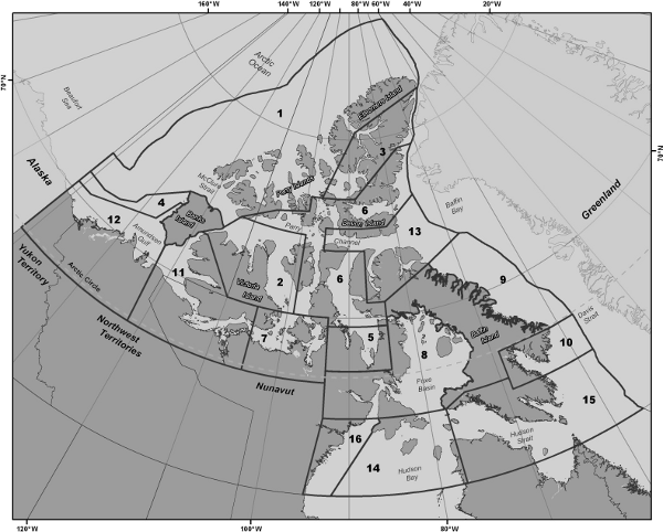
SCHEDULE 2(Section 3)Shipping Safety Control Zones
- SOR/2010-131, s. 8
- Date modified: